Manang Landslide 2026: What Happened in Manang?
Share:
 Read Time
This blog has 3676 words .This blog has 25154 characters.This blog take 12 minutes to read.
Manang has faced a serious combination of floods, landslides, heavy snowfall and an avalanche in late September 2026, creating difficult conditions for local communities, rescue teams and trekkers. The Manang landslide situation developed after several days of persistent rain and snowfall, while a separate avalanche struck the Himlung Himal area in the Nar Phu region.
The situation is especially important for travellers because Manang is one of Nepal’s major mountain destinations. It sits along the Annapurna Circuit and provides access to famous places such as Tilicho Lake, Thorong La and Nar Phu Valley. Although the Manang landslide has damaged roads, bridges and homes, the problems are not the same everywhere in the district. Conditions can change from one valley to another and from lower elevations to higher mountain areas.
The latest reports from September 28, 2026, confirm that two people died in the Himlung avalanche, while 14 Nepali high-altitude workers and guides were still missing as rescue teams continued searching. At the same time, flooding and landslides around Chame and other parts of Manang damaged houses, bridges and roads.
This article explains what happened, where the Manang landslide occurred, what conditions were like beforehand, why the disaster happened, how much damage has been reported, which trekking routes have been affected and what travellers should know before visiting the region.
What Happened in Manang?
The Manang landslide was part of a wider period of severe weather affecting western and central Nepal from September 24 onward. Heavy rainfall affected lower elevations, while snowfall occurred in the higher parts of Manang. Rivers and mountain streams rose quickly, and saturated slopes became more vulnerable to erosion and slope failure.
The situation had already become serious before the major damage was reported. On September 24, the Manang District Administration Office temporarily suspended trekking in several high-altitude areas because forecasts showed heavy to extremely heavy rainfall and snowfall. The restriction covered destinations including Tilicho Lake, Thorong La Pass, Ice Lake, Kang La Pass and Bhimthang.
Despite these warnings, the weather continued to deteriorate. The Manang landslide and flooding then affected roads, bridges, homes and settlements, while the separate Himlung avalanche created a major search-and-rescue emergency.
It is therefore important to understand that the disaster was not caused by one single event. There were several connected hazards occurring during the same period.
Where Did the Manang Landslide Happen?
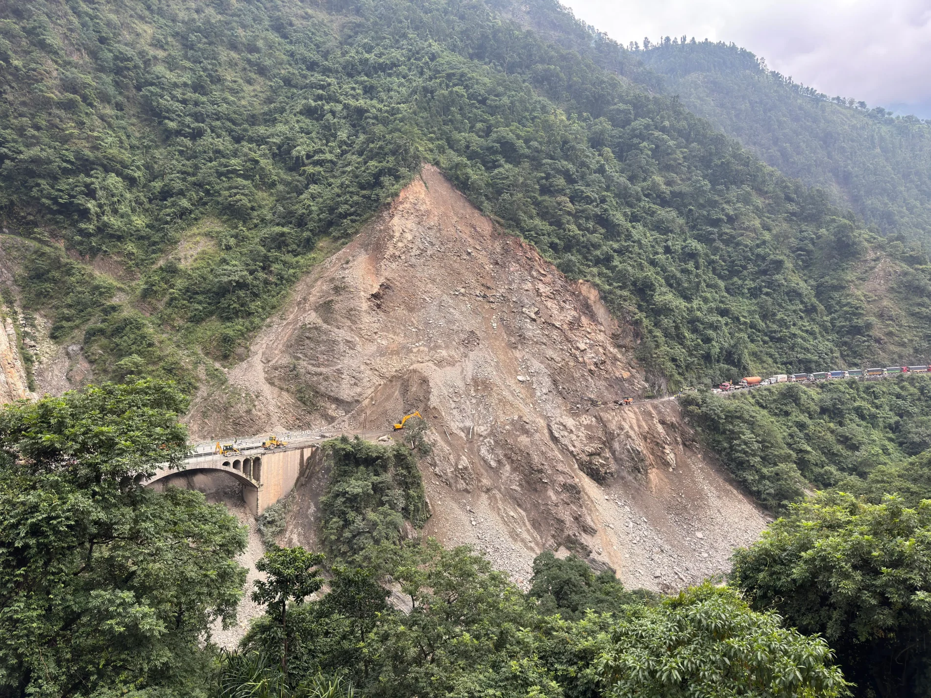
The damage was spread across different parts of Manang District rather than being limited to one single landslide.
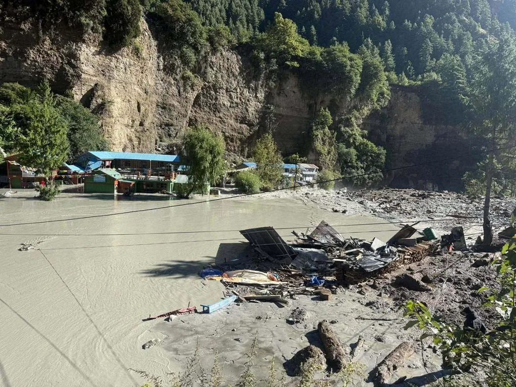
One of the most affected areas was around Chame, the administrative headquarters of Manang. Floodwater and debris from local streams caused damage around the settlement, while debris also entered the Marsyangdi River.
Another important location was Tal village in Nasong Rural Municipality. Floodwater from the Marsyangdi River surrounded the settlement and damaged access roads. Residents were moved to safer places as water entered homes.
Road damage was also reported farther south along the Lamjung-Manang road. At Bagarachhap, around 60 metres of road was washed away. A landslide blocked the road at Khotro, while river erosion damaged another section around Rambazar.
The Manang landslide therefore affected both local communities and the transport connection linking Manang with Lamjung and the rest of Nepal.
What Was the Situation Before the Manang Landslide?
The conditions did not suddenly become dangerous without warning.
Rain had continued for several days, while higher parts of Manang were receiving snow. Snow was reported around Humde at approximately 3,300 metres and in parts of Narpa Bhumi Rural Municipality. Snow was also visible on higher ridges above Chame and toward the Lamjung Himal area.
At lower elevations, rain created a different problem. Mountain streams began carrying larger amounts of water, and saturated ground became more vulnerable to erosion. Roads built beside rivers were particularly exposed because strong water flow could remove soil and road foundations.
Authorities responded by restricting access to high-altitude trekking areas for three days. Trekkers already in the mountains were advised to remain in safe places and avoid moving toward higher elevations until the weather improved.
This warning is important when looking at the Manang landslide because it shows that authorities had already identified a significant weather-related risk before the worst damage occurred.
What Happened at Himlung Himal?
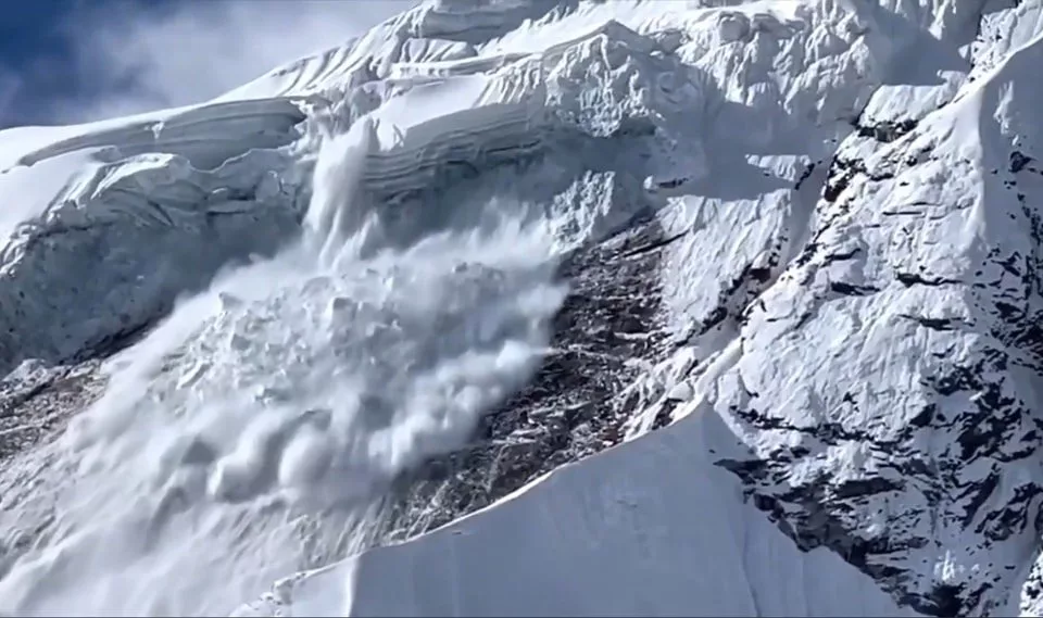
While flooding and the Manang landslide affected the lower parts of the district, an avalanche struck the Himlung Himal area in the Nar Phu region.
Himlung Himal rises to 7,126 metres and is located in the northern part of Manang. The avalanche struck an expedition camp while Nepali workers and guides were preparing the area for an upcoming climbing expedition.
The foreign climbers were reportedly not yet at the camp when the avalanche happened. The people caught in the incident were Nepali high-altitude workers and guides who had travelled to the mountain to prepare the expedition site.
Two bodies were recovered from the avalanche area, and a rescue team was sent toward the base camp by helicopter. As of September 28, reports stated that 14 Nepali workers and guides were still missing.
The Himlung incident should be treated separately from the Manang landslide. An avalanche is a rapid movement of snow and ice down a mountain slope, whereas a landslide normally involves soil, rocks and other ground material moving downhill.
How Did the Himlung Avalanche Happen?
The exact technical cause of the Himlung avalanche has not yet been established through a completed investigation. However, the incident occurred during a period of heavy snowfall, rain and unstable mountain weather.
At high elevations, snowfall can build up layers of snow on steep slopes. When the snowpack becomes unstable, a large mass can suddenly break loose. Weather changes can also alter the strength of different snow layers.
The recent combination of heavy precipitation and difficult conditions increased the danger around high mountain areas.
It would therefore be inaccurate to say that one single factor definitely caused the avalanche. The available reports indicate that the severe weather was an important factor, but the precise avalanche mechanism will require further assessment.
What Happened Around Chame?
The Manang landslide story also includes serious flooding around Chame.
Continuous rainfall caused streams in and around the area to rise. Floodwater carried large amounts of mud, rocks and other debris downstream. Two wooden bridges and two causeways were washed away, while a suspension bridge over the Marsyangdi River in Nasong Rural Municipality was also damaged.
Several homes were affected.
Initial reports said five houses in Chame were completely damaged, while around 10 houses in Tal village were inundated. Later district-wide damage assessments also reported several houses as completely or partially damaged. Because officials were still collecting information, the exact final number may change.
This is common after a large natural disaster. Remote mountain communities can be difficult to reach, particularly when roads, bridges and communication systems are damaged at the same time.
How Did the Manang Landslide Affect the Marsyangdi River?
One of the more unusual parts of the disaster occurred when debris carried by flooding entered the Marsyangdi River near Chame.
The material temporarily obstructed part of the river channel. Authorities monitored the situation because a sudden change in the blockage could alter the river’s flow and create risks downstream.
A warning system along the Marsyangdi River was activated, while authorities kept monitoring the water level.
The Manang landslide therefore created a secondary risk. The immediate problem was not only the debris itself but also what could happen if water accumulated behind it and then suddenly moved through the blocked section.
Later reports indicated that the Marsyangdi water level was receding and there was no immediate major flood threat in the monitored area. Nevertheless, river conditions can change quickly during continued rainfall.
How Much Damage Has the Manang Landslide Caused?
The full damage assessment is still being prepared.
Early reports from Manang identified damage to:
* Houses
* Roads
* Wooden bridges
* Suspension bridges
* Causeways
* Electricity infrastructure
* Communication networks
* Local access routes
* Agricultural and livestock structures
In Manang, police initially reported four houses completely damaged, four partially damaged, one cattle shed destroyed and one bridge completely damaged. Additional reporting from Chame and Tal indicated further flooding and house damage.
The figures should therefore be treated as preliminary rather than final.
The road network has suffered particularly serious damage. Around 60 metres of road was washed away at Bagarachhap, a landslide blocked the road at Khotro, and approximately 50 metres of road around Rambazar was affected by river erosion.
The Manang landslide has consequently created a major transportation problem because several damaged sections are located along the road connecting Besisahar and Manang.
How Much Will It Cost to Repair the Manang Landslide Damage?
At the time of writing, there is no final official figure for the total cost of repairing the Manang landslide damage.
This is because authorities are still assessing the situation. A complete estimate needs to include road reconstruction, bridge replacement, riverbank protection, damaged homes, electricity infrastructure, communication facilities and other public structures.
The Department of Roads has indicated that restoration work on the damaged Lamjung-Manang road will begin as conditions allow. Officials have said that once rainfall stops, some damaged road sections could potentially be reopened within a few days.
However, temporary access and permanent reconstruction are two different things.
Clearing debris from a road may restore traffic relatively quickly, although rebuilding a washed-away road section or bridge can require considerably more time and money.
For this reason, any specific large financial figure published without an official assessment should be treated cautiously.
Which Trekking Routes Have Been Affected?
The Manang landslide and the surrounding weather conditions have affected several trekking areas either directly or indirectly.
Annapurna Circuit
The Annapurna Circuit is one of the routes most relevant to the current situation because its northern section passes through Manang.
Road damage between Lamjung and Manang can affect trekkers travelling toward Chame and the upper Manang Valley. Even when the actual trekking trail remains physically intact, road access can determine whether trekkers can reach or leave particular trailheads.
Tilicho Lake
Tilicho Lake was among the high-altitude destinations temporarily restricted by the Manang District Administration because of the forecast of heavy rainfall and snowfall.
This means travellers should not rely on older trekking itineraries when planning a trip during this period.
Thorong La Pass
Thorong La was also included in the temporary restriction. The pass is located at high elevation, where snowfall and rapidly changing weather can create additional risks.
Nar Phu Valley
The Nar Phu region is particularly relevant because the Himlung avalanche occurred in this broader mountain area.
However, travellers should not assume that every section of the Nar Phu Valley has been destroyed. The confirmed avalanche incident occurred at the Himlung expedition area, while broader access conditions depend on individual trails, weather and local information.
Manaslu Region
The Manaslu trekking area has also experienced poor weather and snowfall, although it is not the same trekking route as the Manang road disaster.
Reports indicated that snowfall had already affected the Manaslu Base Camp area for around two weeks, while authorities warned of rain, landslides, rockfalls and rising river levels.
Why Did the Manang Landslide Happen?
There is rarely one reason behind a major mountain landslide.
In this case, several factors came together.
Prolonged rainfall
Continuous rainfall increases the amount of water entering soil and loose rock. As the ground becomes saturated, its stability can decrease.
Strong river flow
Rivers and mountain streams can erode the sides and foundations of roads. When water removes supporting material, roads and slopes can collapse.
Steep mountain terrain
Manang is surrounded by steep Himalayan terrain. Water moving quickly down steep slopes has considerable erosive power.
Snow and changing temperatures
At higher elevations, heavy snowfall creates a separate hazard. When snow accumulates on steep slopes, avalanche risk can increase.
Weak infrastructure points
Roads and bridges located close to rivers are naturally exposed to flooding and erosion. Temporary crossings can also be particularly vulnerable during extreme weather.
The Manang landslide was therefore the result of a combination of intense weather, steep terrain, flowing water and vulnerable infrastructure rather than one isolated cause.
How Many People Have Died?
The confirmed death toll connected specifically to the Himlung avalanche is two as of September 28, 2026.
Fourteen Nepali high-altitude workers and guides were still reported missing as rescue teams continued searching.
It is important not to combine this figure with the wider death toll from floods and landslides across Nepal or Gandaki Province. Those are separate statistics covering a much larger geographical area.
The Manang landslide and flooding around Chame have caused substantial damage, but the latest reports available at the time of writing did not establish an additional confirmed death toll from the Chame flooding itself.
Because rescue and assessment operations were still underway, the figures may change as authorities receive more information.
What Has Been the Impact on Local Communities?
The effects extend far beyond trekking.
People living in Manang depend on roads for food, construction materials, fuel, medical supplies and other essential goods. When a road is blocked, even a short damaged section can isolate communities.
The flooding also affected homes in low-lying settlements. Tal village was particularly vulnerable because the Marsyangdi River surrounded the settlement during the flooding.
Electricity and mobile communication were also disrupted in parts of the district. This made rescue coordination more difficult and created problems for people trying to contact family members or authorities.
The Manang landslide has therefore affected daily life as well as tourism.
What Is Happening With Rescue Operations?
Rescue teams have been working in difficult conditions.
A search team travelled toward the Himlung base camp by helicopter, while additional mountain rescue personnel were mobilised to search for the missing workers and guides.
The high altitude, snow, poor weather and difficult terrain make the operation considerably more complicated than a normal ground rescue.
Helicopters are useful in reaching remote mountain areas, although weather conditions can prevent or delay flights.
The recovery of the first two bodies allowed authorities to confirm that the avalanche had caused fatalities. The search for the remaining missing people continued on September 28.
What Does the Manang Landslide Mean for Trekkers?
For trekkers, the most important lesson is that the situation should not be judged simply by looking at a route map.
A trekking trail can remain open while the road leading to it is damaged. A lower valley can experience flooding while a higher trail is covered in snow. A clear morning can also be followed by rapidly worsening weather in the mountains.
The Manang landslide has made route-by-route information particularly important.
Travellers should check:
* Current weather forecasts
* Local trekking restrictions
* Road conditions
* Trail conditions
* River levels
* Bridge conditions
* Local government notices
* Conservation-area updates
* Information from their guide or trekking operator
Trekkers should also avoid crossing flooded streams, damaged bridges or unstable slopes simply because an itinerary says they should reach a particular village that day.
Is Manang Safe for Trekking Now?
There is no useful single answer for the entire Manang district because conditions vary by location and elevation.
The important point is that some areas have experienced direct flooding, road damage and landslides, while higher areas have faced snow and avalanche risks.
Authorities had already temporarily restricted several high-altitude trekking destinations before the major incidents occurred.
Therefore, anyone planning to enter Manang should check the latest local information before departure rather than relying on an old trekking report.
If a road is officially closed, travellers should not attempt to bypass the damaged section independently. Similarly, if local authorities restrict access to a high-altitude trail, the restriction should be taken seriously.
What Will Happen to the Roads After the Manang Landslide?
Road restoration is expected to happen in stages.
First, authorities need to clear mud, rocks and other debris from accessible sections. After that, damaged road foundations need to be assessed.
Where rivers have removed parts of the road, simply placing gravel on the surface may not be enough. The underlying section may need reconstruction and protection against further erosion.
Bridges and causeways will require separate assessment. Temporary crossings may restore movement sooner, while permanent bridges could take longer to rebuild.
The Department of Roads has already indicated that work on the damaged Lamjung-Manang connection will begin. Officials have suggested that some sections could become passable after rainfall stops and emergency repairs are completed.
However, this does not mean that every damaged section will receive a permanent solution within a few days.
What Does the Disaster Mean for the Autumn Trekking Season?
September and October are normally important months for trekking in Nepal because autumn often provides favourable mountain conditions.
The current Manang landslide situation, however, shows why the beginning of trekking season does not automatically mean every route is ready.
The weather has been unusually disruptive, and several mountain destinations have experienced rain, snow, floods or landslides.
This does not mean that trekking throughout Nepal has stopped. Conditions differ significantly between destinations.
Instead, travellers need to look at their specific route and the conditions on the day they plan to travel.
For the Annapurna region, road access and local weather will be particularly important. For high-altitude routes, snow and avalanche conditions also need to be considered.
What Can Travellers Learn From the Manang Landslide?
The biggest lesson is simple: mountain travel requires flexibility.
A trekking plan may look perfect on paper, although weather and natural conditions can change it within hours.
Travellers should leave enough flexibility in their itinerary for delays. They should also avoid planning important international flights immediately after a high-altitude trek when possible.
Communication is another important factor. Mobile service is not guaranteed in remote mountain areas, and the recent disruption in Manang shows how quickly communication can become difficult during a disaster.
A local guide can also provide information that may not yet appear online, particularly when road conditions change quickly.
Why Choose Silver Moon Adventure?
When conditions change in the mountains, responsible trekking is not simply about following a fixed itinerary.
Silver Moon Adventure focuses on practical coordination, local communication and route awareness so travellers can make informed decisions when weather, road conditions or local restrictions affect a planned journey.
For international travellers, this local connection can be particularly useful because information from a mountain village may change before it reaches larger travel platforms.
The Manang landslide is also a reminder that a good trekking experience depends not only on reaching the destination but on making sensible decisions throughout the journey.
Frequently Asked Questions
1. What happened in Manang in September 2026?
Manang experienced heavy rain, flooding, landslides and snowfall in late September 2026. A separate avalanche struck Himlung Himal in the Nar Phu region, killing two people and leaving 14 Nepali high-altitude workers and guides missing as of September 28.
2. Where did the Manang landslide happen?
Damage occurred at several locations across Manang, including areas around Chame, Tal village and the Lamjung-Manang road. Bagarachhap, Khotro and Rambazar were among the locations where serious road damage or blockages were reported.
3. What caused the Manang landslide?
The immediate conditions included prolonged heavy rainfall, swollen rivers and mountain streams, saturated slopes and river erosion. The district’s steep terrain also increases the potential for slope failures during intense rainfall.
4. How many people died in the Himlung avalanche?
Two deaths had been confirmed as of September 28, 2026. Fourteen Nepali workers and guides remained missing while rescue teams continued their search.
5. Was the Himlung incident a landslide?
No. The Himlung incident was an avalanche involving snow and ice. The flooding and ground failures around Chame and other parts of Manang were separate landslide and flood-related events.
6. Is the Annapurna Circuit affected by the Manang landslide?
Yes, parts of the Annapurna Circuit can be affected by the current road and weather conditions because the route passes through Manang. Road damage between Lamjung and Manang can make access difficult even where individual trekking trails remain usable.
7. Is Tilicho Lake affected?
Tilicho Lake was among the high-altitude destinations temporarily restricted by the Manang District Administration during the period of heavy rainfall and snowfall. Travellers should check the latest local notice before attempting the route.
8. Is Nar Phu Valley affected?
The Nar Phu region is associated with the Himlung avalanche area, so travellers should obtain current local information before entering. However, the avalanche at the Himlung expedition camp should not be interpreted as proof that the entire Nar Phu trekking route has been destroyed.
9. Is Manang open for tourists?
Conditions vary across the district. Some roads and infrastructure have been damaged, while high-altitude areas have experienced snow and temporary restrictions. Travellers should check current conditions before travelling and follow instructions from local authorities.
10. How much will it cost to repair the Manang landslide damage?
A final official repair estimate was not available as of September 28, 2026. Authorities are still assessing damage to roads, bridges, houses and other infrastructure, so any exact figure published before a complete assessment should be treated cautiously.
Final Thoughts
The Manang landslide situation of September 2026 is more than a road blockage or a temporary disruption to trekking. It has affected communities, transport infrastructure and mountain expeditions, while the Himlung avalanche has created a separate and serious rescue operation.
The most important point for travellers is that the situation is still developing.
Two people have been confirmed dead in the Himlung avalanche, 14 people were still missing on September 28, roads have been damaged, bridges have been washed away and several high-altitude trekking areas have faced restrictions because of dangerous weather.
At the same time, this does not mean that every trekking destination in Nepal has been affected in the same way.
Mountain conditions can change quickly, although reliable local information can help travellers make better decisions. Anyone planning to travel through Manang should therefore check current road conditions, weather forecasts, trekking restrictions and local guidance before setting out.
The Manang landslide may eventually become a road-repair story, but for now it remains an active disaster-response situation. The safest approach is to follow verified updates, respect local restrictions and give rescue and recovery teams the space they need to work.
Photos Credits: Ratopati and Onlinekhabar
All rights belong to the respective photographers and publishers.

Similar Blogs
View all
13/10/2026
Manaslu Circuit Trek After the October 2026 Floods: Trail Conditions, Safety and Travel Updates
The Manaslu Circuit Trek is one of Nepal’s most rewarding Himalayan journeys, taking trekkers through traditional...
Read more
13/10/2026
Your Nepal Trek Is Booked, but the Trail Is Closed: What Now?
Imagine arriving in Nepal with your trekking boots ready, your flights booked, your bags packed, and...
Read more